
Microsoft today announced a slew of new capabilities for Azure Maps, its enterprise geospatial suite. The additions include a software development kit (SDK) for Android, cloud-based services, map tiles, and integration with Azure Active Directory. Additionally, several services — including Route Range, Get Search Polygon, and Satellite and Hybrid Imagery — have moved from public preview to general availability.
“The mobility space is at the forefront of the most complex challenges faced by cities and urban areas today. The movement of people and things is as much a driver of opportunity as it is an agent of chaos, aggravating existing challenges of traffic, pollution, and unbalanced livelihoods,” Chris Pendleton, principal PM manager at Azure Maps, wrote in a blog post. “The services we’re introducing are designed exclusively for the needs of the modern enterprise customer — powerful, real-time analytics and seamless cross-screen experiences, fortified by robust security services.”
First up is an enhanced map canvas with a set of natural earth map tiles, and a new image compositor that Microsoft says makes interactions more “aesthetic” and “powerful” by enabling the rendering of raster maps with annotated points, lines, and polygons. Also making its debut in preview is the aforementioned Android SDK, which comes with rendering maps and traffic, drawing tools, event handling, and a variety of map canvases; it also supports Azure Maps services such as Search and Routing.
June 5th: The AI Audit in NYC
Join us next week in NYC to engage with top executive leaders, delving into strategies for auditing AI models to ensure fairness, optimal performance, and ethical compliance across diverse organizations. Secure your attendance for this exclusive invite-only event.
Azure Maps Web SDK 2.0, a web-based module for accessing Azure Maps, is launching alongside the Android SDK. In addition to Azure Active Directory integration (more on that later), it introduces stroke gradients (i.e., the ability to fill a line with a gradient of colors to show transition from one segment of a line to the next), a Shaded Relief map style that shows the contours of the Earth, and polygon fill patterns and native control for shapes, borders, and fills.
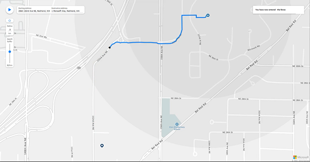
Additionally launching in preview is Azure Maps Spatial Operations, a service that takes location information and analyzes it in real time to enable predictive modeling of events. Its Geofencing component lets Azure Maps users store coordinates in the shape of customizable polygons in the new Azure Maps Data Service (up to 50MB) and create notifications with Azure Event Grid that trigger whenever an object enters, exits, or changes proximity to a geofence.
Tech firm Tagdat is already using geofencing to warn construction site visitors when entering hazardous zones, Microsoft says.
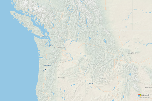
Above: The new Shaded Relief canvas.
Buffer, another tool that’s a part of Spatial Operation, allows users to build an area around points, lines, and polygons based on a given distance, while Closest Point returns the closest points between a base point and a given collection of points. Meanwhile, Great-Circle Distance returns the shortest distance between two points on the surface of a sphere, and Point in Polygon returns a Boolean indicating whether the location is inside a given set of Polygon and MultiPolygon geometries.
Microsoft today also took the wraps off of Azure Active Directory integration in preview, which can be used to implement secure access by providing role-based access control (RBAC) and authenticate apps and Azure Active Directory users. In addition, it supports managed identities for Azure resources.
The new Azure Maps features come a week after Microsoft announced it would use TomTom’s location-based services for cloud services like Microsoft Azure, Bing Maps and Cortana.
