Watch all the Transform 2020 sessions on-demand here.
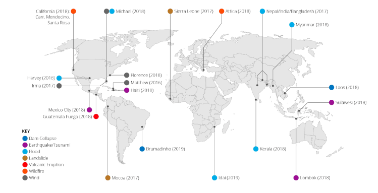
As climate change escalates, the impact of natural disasters is likely to become less predictable. To encourage the use of machine learning for building damage assessment this week, Carnegie Mellon University’s Software Engineering Institute and CrowdAI — the U.S. Department of Defense’s Joint AI Center (JAIC) and Defense Innovation Unit — shared plans to open-source a labeled data set of some of the largest natural disasters in the past decade. Called xBD, it covers the impact of disasters around the globe, like the 2010 earthquake that hit Haiti.
“Although large-scale disasters bring catastrophic damage, they are relatively infrequent, so the availability of relevant satellite imagery is low. Furthermore, building design differs depending on where a structure is located in the world. As a result, damage of the same severity can look different from place to place, and data must exist to reflect this phenomenon,” reads a research paper detailing the creation of xBD.
xBD includes approximately 700,000 satellite images of buildings before and after eight different kinds of natural disasters, including earthquakes, wildfires, floods, and volcanic eruptions. Covering about 5,000 square kilometers, it contains images of floods in India and Africa, dam collapses in Laos and Brazil, and historic deadly fires in California and Greece.
The data set will be made available in the coming weeks alongside the xView 2.0 Challenge to unearth additional insights from xBD, coauthor and CrowdAI machine learning lead Jigar Doshi told VentureBeat. The data set collection effort was informed by the California Air National Guard’s approach to damage assessment from wildfires.
June 5th: The AI Audit in NYC
Join us next week in NYC to engage with top executive leaders, delving into strategies for auditing AI models to ensure fairness, optimal performance, and ethical compliance across diverse organizations. Secure your attendance for this exclusive invite-only event.
“This process informed a set of criteria that guided the specific data we targeted for inclusion in the data set, as well as weaknesses of the current damage assessment processes. Each disaster is treated in isolation. The process human analysts use is not repeatable or reproducible across different disaster types. This irreproducible data presents a major issue for use by machine learning algorithms; different disasters affect buildings in different ways, and building structures vary from country to country, so determinism in the assessment is a necessary property to ensure machine learning algorithms can learn meaningful patterns,” the report reads.
The group also released Joint Damage Scale, a building damage assessment scale that labels affected buildings as suffering “minor damage,” “major damage,” or “destroyed.” The images were drawn from DigitalGlobe’s Open Data program.
xBD was one of dozens of works presented earlier this week at Computer Vision and Pattern Recognition (CVPR) 2019, held in conjunction with the Computer Vision for Global Challenges workshop. The workshop received submissions from 15 countries.
Other work presented at the conference included research on things like spatial apartheid in South Africa, deforestation prevention in Chile, poverty prediction from satellite imagery, and penguin colony analysis in Antarctica.
In addition to its contributions to xBD, CrowdAI worked with Facebook AI last year to develop systems for damage assessment methods derived from Santa Rosa fire and Hurricane Harvey satellite imagery. This project was based on work from the DeepGlobe satellite imagery challenge from CVPR 2018.
Facebook AI researchers are also using satellite imagery and computer vision that identifies buildings in order to create global population density maps. The initiative started in April with a map of Africa hosted by the United Nations Humanitarian Data Exchange.
Also part of CVPR this year, researchers from Wageningen University in the Netherlands presented work that explores weakly supervised methods of wildlife detection from satellite imagery, technology with applications for animal conservation.
Other highlights from CVPR 2019:
- Microsoft GANs that can create images and storyboards from captions
- Nvidia AI that improves existing computer vision systems and existing object detection systems
- AI that can see around corners
- Cruise open-sourced Webviz, a tool for robotics data analysis


