Watch all the Transform 2020 sessions on-demand here.
Some of the world’s most disaster-prone areas are poorly mapped, exacerbating the challenge for rescuers tasked with finding displaced persons. OpenStreetMap, a collaborative project to create a platform-agnostic world atlas, has a volunteer team targeting the gaps (the Humanitarian OpenStreetMap Team) that’s identified 11 million square kilometers in Africa alone to date. But millions of square kilometers remain unreviewed, uncurated, or otherwise uncatalogued.
That’s motivated a partnership announced today between Microsoft’s Bing Maps team, Microsoft Philanthropies, and the Humanitarian OpenStreetMap Team, which will seek to bring new machine learning approaches and open building corpora into OpenStreetMap’s auditing tools. It’s under the umbrella of Microsoft’s AI for Humanitarian Action program, a $40 million five-year plan unveiled in September 2018 to support developers interested in creating services with the goal of helping humanity.
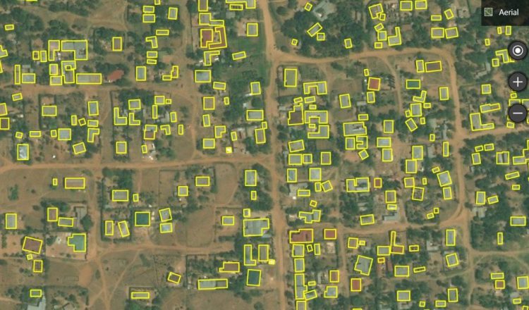
As a first step, Bing Maps engineers will release country-wide building footprint data sets for Uganda and Tanzania, created with feature-identifying computer vision algorithms. Microsoft claims it’ll be one of the first open building data sets for Africa, with 7 million building footprints in Uganda and 11 million in Tanzania for a total of 18 million footprints total. (It joins OpenStreetMap’s 14 million footprints in those countries.)
Microsoft says they’ll soon be available from GitHub, ahead of scheduled presentations on the work by the Bing Maps team at the annual International State of the Map conference in Heidelberg, Germany and at the Humanitarian OpenStreetMap Team Summit.
June 5th: The AI Audit in NYC
Join us next week in NYC to engage with top executive leaders, delving into strategies for auditing AI models to ensure fairness, optimal performance, and ethical compliance across diverse organizations. Secure your attendance for this exclusive invite-only event.
“Machine learning datasets for OSM need to be open. We need to go beyond identifying roads and buildings and open datasets allow us to experiment and uncover new opportunities,” said Tyler Radford, executive director of the Humanitarian OpenStreetMap Team, in a statement. “Open Building Dataset gives us the ability to not only explore quality and validation aspects, but also advance how ML data assists mapping.”
Creating the data sets wasn’t easy, according to Microsoft. Africa’s unique settlements, dense urban areas with connected structures, imagery quality, and lack of training data were formidable barriers. To overcome them, the Bing Maps team homed in on areas with poor recall by leveraging population estimates from Columbia’s Center for Earth Science Information. This improved model recall in rural areas substantially, aiding in subsequent labeling efforts.
Microsoft’s contributions coincide with Facebook’s collaboration with OpenStreetMap, which resulted in the development of a tool — Map With AI — that automates several of the most time-consuming steps involving in annotating roads, buildings, and bridges. Additionally, the Menlo Park company recently made available TapiD, RapiD, and an AI-powered version of OpenStreetMap’s editing tool iD, in addition to AI-generated road mappings in Afghanistan, Bangladesh, Indonesia, Mexico, Nigeria, Tanzania, and Uganda.